Those who live in the area might not realize that one corner of North Surrey was among the very first Canadian examples of urban planning, more than a century ago.
Lorne Circus is “the incomplete realization of a grand urban planning scheme, with a radial street pattern laid out around a central roundabout in a residential area,” according to an explanation on the Canada’s Historic Places website (historicplaces.ca).
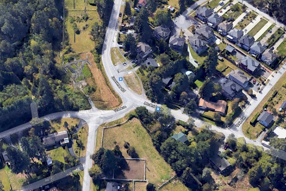
Originally conceived around 1910, the plan partially survives at the intersection of Grosvenor Road, McBride Drive, Bedford Drive and 114 Avenue, in the Port Mann neighbourhood of Surrey.
In this case, “circus” has nothing to do with clowns, trapeze performers or jugglers.
In urban planning, a circus is an open area where several streets join together, as in London’s famous Piccadilly Circus. These junctions are intersections of so many roads that they become circular, hence circus.
It’s not clear if Surrey’s circus is named for any Lorne in particular (someone please educate this reporter), but the traffic corner is given heritage value as “one of the first Canadian examples of urban planning, based on scientific principles,” the Canada’s Historic Places website notes.
“Port Mann was planned as a new industrial city with streets radiating from a central circus in the residential section. The proposed business section was designed to cluster around a large open square.”
An aerial view of the intersection shows Grosvenor Road curving before 114 Avenue to become McBride Drive, west of Bon Accord Creek and the popular Invergarry Bike Park.
Several curved drives to the south, including Currie, Gladstone, Melrose, Kindersley and Park, follow the radius of the original Lorne Circus.
(STORY CONTINUES BELOW)
PICTURED: A view of the incomplete Lorne Circus in North Surrey, at the intersection of Grosvenor Road, 114 Avenue and McBride Drive. (Photo: Google Street View)
The City of Surrey’s website notes Lorne Circus as #215 among heritage sites in Whalley.
“This partially built traffic circle,” says a post on surrey.ca, “is one of the most recognized elements of the 700-acre planned area subdivided around 1910, to form a comprehensively planned community consisting of single family lots, parks, commercial and port facilities. This exemplifies the long-standing efforts to establish a good quality of life in the City through well planned neighbourhoods, parks, and road systems.”
In the Port Mann area, the New Westminster Southern Railway established a stop in 1891 at Bon Accord, then a fishing settlement that included a landing where steamboats refuelled, says a post on historicplaces.ca.
In 1911, Sir Donald Mann and Sir William MacKenzie, co-builders of the Canadian National Railway, established Port Mann as their western terminus and a rival to Vancouver. “Despite the development of extensive rail yards and warehouses at Port Mann, the CNR’s grandiose plans for a major urban centre failed to materialize.”
Landscape architect Fredrick G. Todd supervised the planning of Port Mann, and designed “some of Canada’s most beloved places,” including Bowering Park in St. John’s, Mount Royal Park and the Town of Mount Royal in Montreal, Leaside in Toronto and Shaughnessy Heights in Vancouver. Todd popularised naturalistic landscape designs, including the idea of a “necklace of parks” as linked open space.
• SURREY NOW & THEN: ‘Good memories’ in magic man’s prominent home, destroyed by fire.
Four blocks southwest of Lorne Circus, famous magician Leon Mandrake once lived in a house located at Grosvenor Road and Kindersley Drive. The Mandrake family home was a repurposed corner store where the patriarch was known to entertain visitors with a trick or two, starting in the mid-1950s.
In the heat of August 2016, more than two decades after the Mandrakes vacated in 1994, the abandoned house burned to the ground, ending any chance of city hall giving the structure heritage-protection status, as had been considered.
CLICK HERE to read more Surrey Now & Then stories.
tom.zillich@surreynowleader.com
Like us on Facebook Follow us on Instagram and follow Tom on Twitter